Well, no. That may come later, but for now Valdosta has the Azalea City Trail.
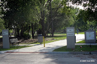
 The Azalea City Trail is a paved, urban trail that runs 2.63 miles from the Vallotton Youth Complex (700 Woodlawn Drive) to the Craig Center (1104 W Gordon St). The east end of the trail at the Vallotton Youth Complex looks encouraging. Starting next to a good-sized parking lot, the trailhead is well-marked by signs and a detailed map of the route. The trail itself is a twelve-foot wide concrete strip that curves away to the south. So far, so good.
 Less than 200 yards later "STOP" signs on the trail mark the crossing of Vallotton Drive. Once across the road, the trail curves through Vallotton Park, reaching the banks of One Mile Branch Creek. Then it's time to cross North Lee Street. This takes you into a wooded area around a stormwater retention pond, home to Canadian geese who have almost certainly never seen Canada. The trail rounds the pond, crossing a small bridge. Then, after just over half a mile, the trail dumps you onto a sidewalk on Marion Street. It's a nice sidewalk, but it's just a sidewalk.
For
 half a mile the trail follows sidewalks, south on Marion Street, west on East Ann Street, and north alongside Bazemore-Hyder Stadium on William Street. Past the stadium, you cross East Brookwood Drive into Drexel Park and return to something that is indisputably a trail. This takes you through the park and across North Patterson Street onto the campus of Valdosta State University. Once on campus, the trail winds pleasantly along One Mile Branch for almost a quarter mile before returning to sidewalk briefly to cross North Oak Street. The trail isn't particularly well marked at Oak Street, and it isn't clear whether you're supposed to use the pedestrian bridge or go south to the crosswalk (it's the crosswalk).
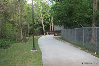
 Across North Oak Street, the trail runs between Sunset Hill Cemetery on the south and Valdosta State on the north to Sustella Avenue. After crossing Sustella Avenue you come to the best part of the trail, a 0.4-mile wooded stretch along One Mile Branch. Owls call from the trees. One Mile Branch may be mostly a drainage canal, but its water chatters just as merrily as if it were a mountain stream. There are lights, even though the posted "Rules of the Trail" indicate that this part of the trail is closed after sundown.
 This sylvan portion of trail ends at Wainwright Drive, where the trail turns south, away from One Mile Branch, up a hill, on a sidewalk. For a quarter mile, along Wainwright, Brookhaven Drive, and Rosewood Drive, narrow sidewalks are passed off as "trail." Finally, at west end of Rosewood, you're back on a twelve-foot wide paved path. This takes you a few hundred yards to the Craig Center and the west end of the Azalea City Trail.
As
 paved trails go, the Azalea City Trail is on the short side, and almost a mile of it is on relatively un-trail-like sidewalks. Considering the amount of development in the area, it's probably remarkable that Valdosta was this successful in coming up with a nearly continuous trail route. Indications are that the west end of the trail will eventually link to a project called the Withlacoochee River Greenway, but neither the link nor the greenway yet exist. As it stands, the Azalea City Trail is useful locally for fitness and "alternative transportation," and some of it could be used as part of a road-race course. It's worth checking out if you're in Valdosta, but don't make a special trip.
Links:
- Map of the Azalea City Trail
https://www.box.com/s/nuti93eqjal7jcusvqgd
- 8 May 2010 article about the Azalea City Trail
http://valdostadailytimes.com/local/x1341939541/On-the-trail
This is still a trail that could use some help these 11 years later. But it is about all we have available here in Valdosta.
ReplyDeleteThere are some other opportunities for Valdosta-area trails, but nothing that has been taken advantage of. For instance....
DeleteA few years ago when I was in Madison, Florida, a local gentleman told me a story about how he and a buddy had been in Clyattville late one evening. I'm not sure why they were in Clyattville. Perhaps there was more there back then, or perhaps there was even less in Madison. This evening was, after all, long enough ago that the railroad still ran from Clyattville to Madison. And when it was time to go back to Madison, these two youths decided to make the return trip by driving on the railroad.
They didn't run into a train. They didn't run the car off the trestle across the Withlacoochee River. He did mention that when he opened the car door mid-river, he couldn't see anything below them but aside from the water.
Anyway, the tracks have since been removed south of Clyattville. Madison County has turned their stretch of the rail grade between Madison and the river into the Four Freedoms Rail Trail, about a dozen miles of paved path.
It seems like Lowndes County could turn their stretch of the abandoned grade into a rail trail as well. And if Florida and Georgia could get their acts together, the two trails could be linked with a bridge over the Withlacoochee River (the old trestle is in ruins). That would make for about eighteen miles of paved trail from Cylattville to Madison.